
For the 10 days leading up to New Year’s Eve, we’d had a lot of rain in the southern Appalachians. Really, it was a tremendous stretch of wet weather. So, I just had to get out and look for some waterfalls once the clouds finally parted. My destination was the Davidson River area of Pisgah National Forest, where many well-known falls (such as Looking Glass) are located. Specifically, I was headed to the base of the Pisgah Ridge which stands to the northwest of the more level areas around the Pink Beds.
Many streams coming off that line of mountains sports a waterfall, it seems, just before spilling out into the flatter areas below. I’m not sure what the geology is that spurs this, but I’d already explored one waterfall on the stream beside the Barnett Branch trail, and I’d seen pictures of one waterfall on Pigeon Branch, another on Poundingmill Branch, another in Bennett Cove, and one on a stream in between. Further south, of course, there is Log Hollow Falls and a waterfall on each tributary north and south of that.
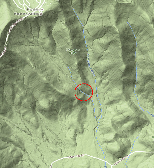
All are clearly visible on the high-detail terrain maps available nowadays, which are far better at revealing waterfalls hidden under the tree canopy than the old USGS topo maps ever were. So after browsing the maps, I found another stream draining the ridge where I suspected I’d find some falling water – a tributary of Thompson Creek. It’s the stream that drains the slope right below the Pisgah Inn on the Blue Ridge Parkway, near Flat Laurel Gap, and it exhibits that same familiar “kink” pattern on the map right where it crosses the foot of Thompson Ridge.
I’d not seen any photos of a waterfall on that stream so I figured it’d be a good one to explore and document if my hunch was correct. So that became my primary target as I headed out on a partly cloudy day, with temps in the 50’s – far cooler than we’d had in the preceding week where it’d been in the 70’s, but still warm for late December and perfect weather for my planned activities. I decided the waterfall on Poundingmill Branch would be my backup/second destination.
Before even arriving at my first hike, though, I was treated to scads of other wet-weather falls as I drove up US 276 from Brevard. There was one visible across the Davidson River just before the Coontree picnic area, on Stillwater Branch, for example. There’s a waterfall on a tributary between Looking Glass Falls and Moore Cove, which you’d never see except in winter with tons of water flow. It’s at a small pullout with a picnic table, up the cove across the creek. There was a waterfall visible in the tiny drainage east of Moore Cove – not too big, but a flash of free-falling water clearly visible through the woods nonetheless. And there were at least two of them – high ones – coming off Looking Glass Rock just south of Sliding Rock, visible from a pull-off on US 276 above a larger cascade on Looking Glass Creek.
And these were just the ones visible from the road! Imagine how many little falls must be tucked away in the folds of these hills when the water pours like this. I was doing just that as I drove down Yellow Gap Road (FS 1206) into the parking area for my first hike. Luckily, the gate was still open and I was able to drive all the way to the Thompson Creek trailhead as I had planned.
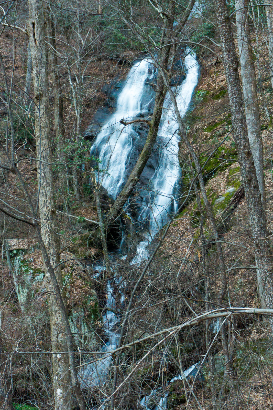
In almost no time, I was able to determine that the suspect tributary has a nice series of falls indeed. The “kinks” in the stream bed visible on the map were just upstream of where the Thompson Creek Trail crosses the tributary. And there’s not much to say about this one except that after a short hike on the trail, crossing the tributary, and taking a left upstream through the woods, I very shortly arrived at a waterfall just like I had expected. And it was actually a pretty nice one!
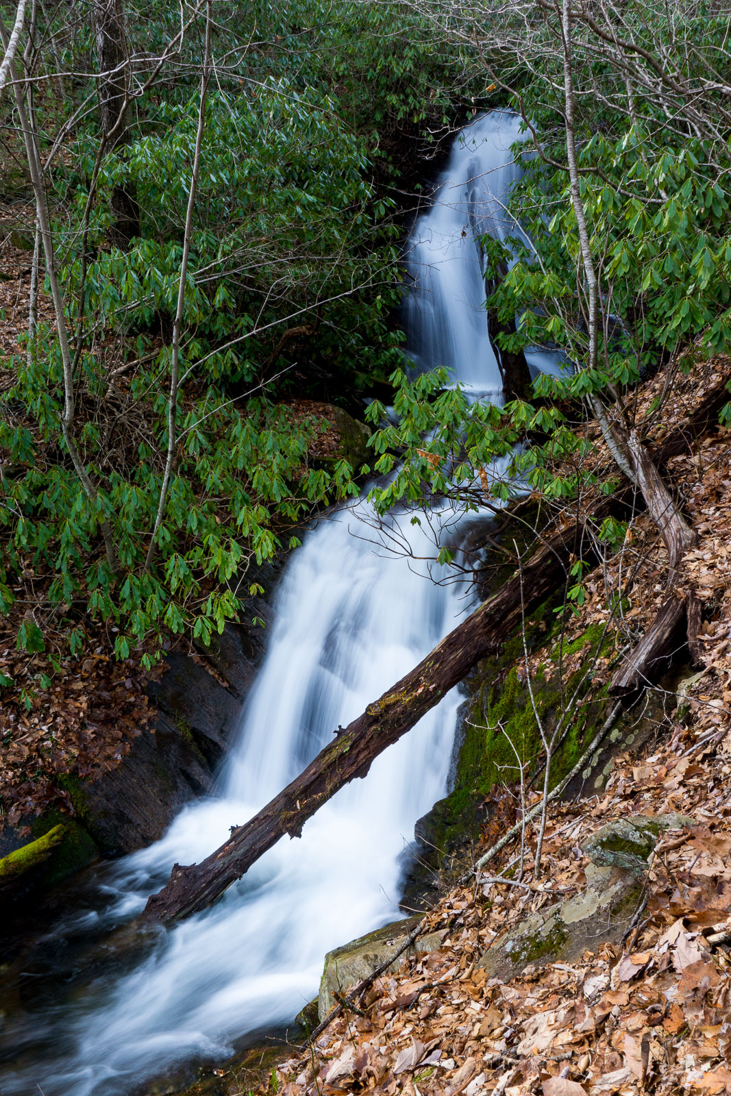
That drop wasn’t enough of an elevation difference to account for what I’d seen on the map, though, and I suspected more sections of falls were upstream. So up I went, and there were. Trouble is, they weren’t nearly as nice as the lowermost drop, and they were far more difficult to reach. I had to clamber up slopes way too steep for safety and comfort, and claw my way through curtains of stabbing greenbrier before confirming that the waterfalls existed. Here’s some pics of the middle and upper sections:
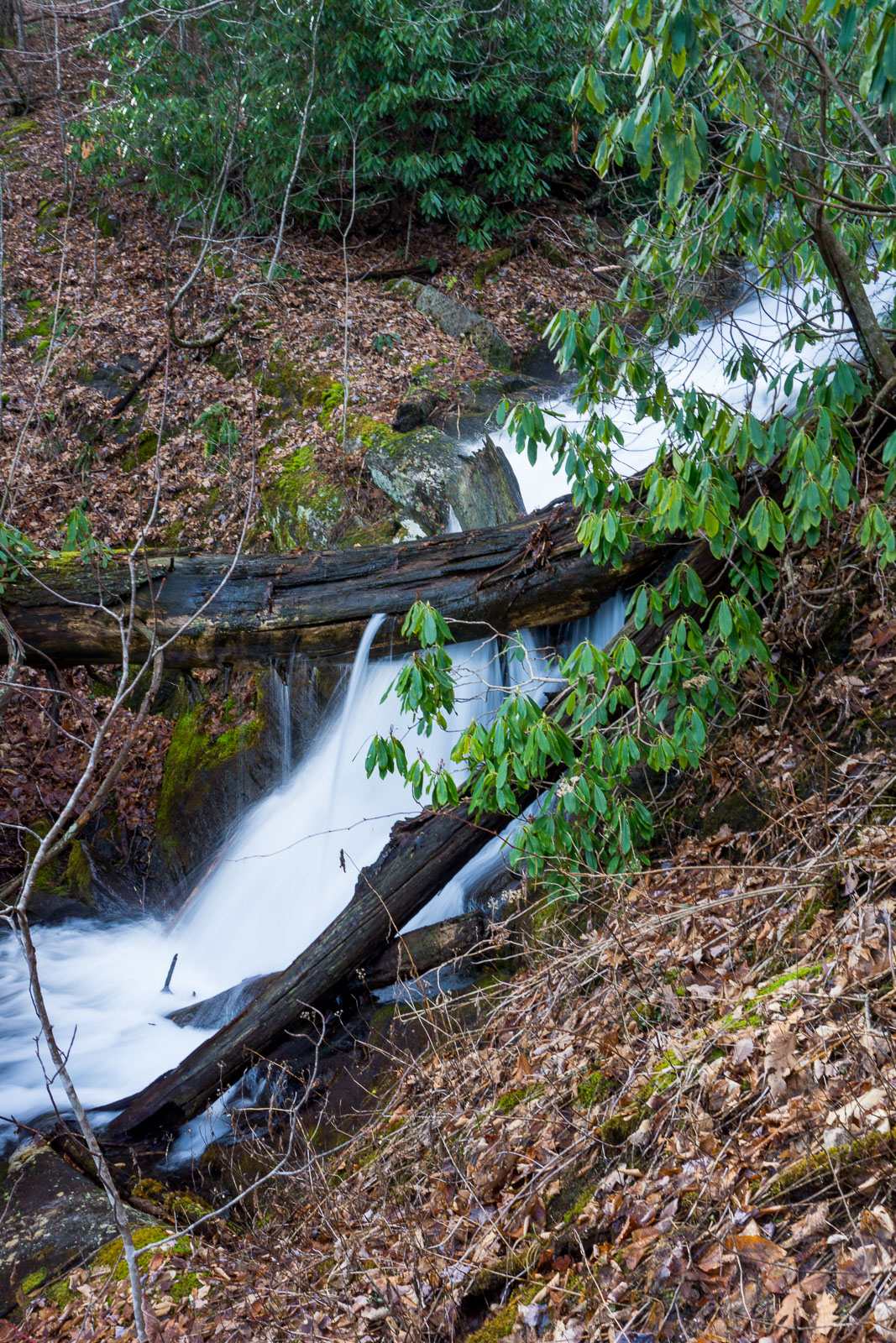
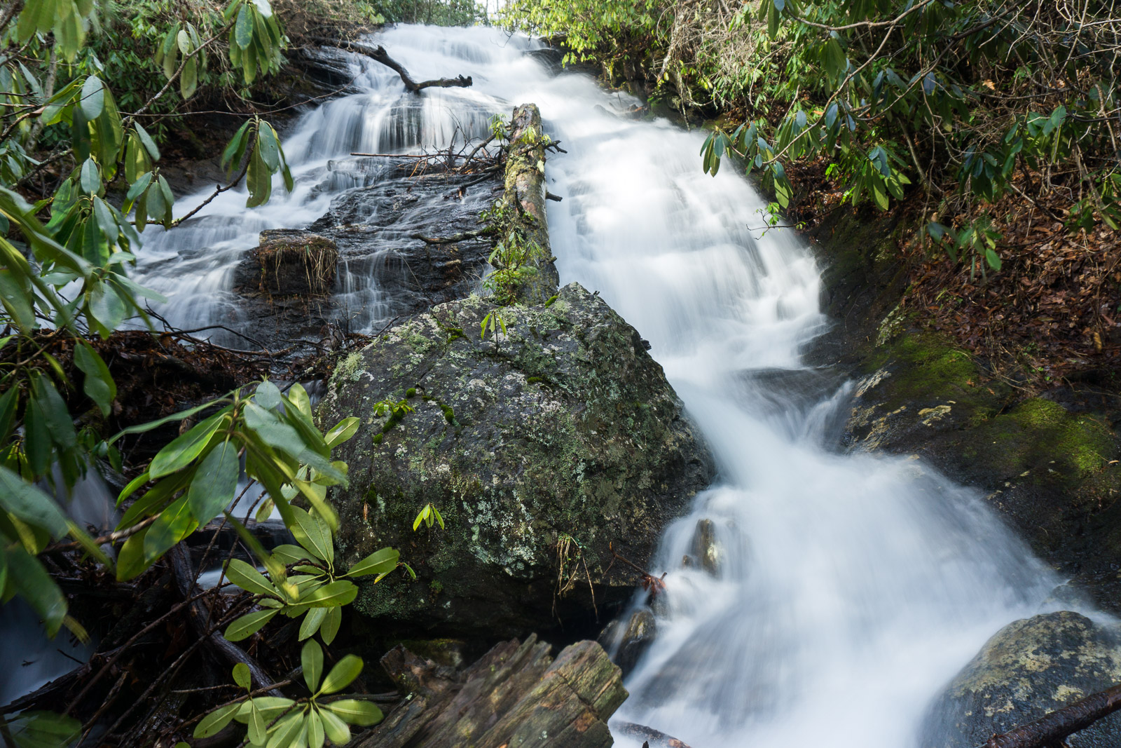
I probably won’t be visiting these again, as doing so would undoubtedly cause damage to the area. It’s just too easy to dislodge the thin soil overlying the rocks despite my best efforts. The upper drops would also be disappointing visually in anything less than very high water. Do check out the lower drop, but unless you simply must knock them off your list I don’t really recommend trying to reach the upper two at all. But I guess I’m glad to have the pictures!
Having knocked that off the list with time to spare, I headed back to the car and drove back to US 276, past the Pink Beds picnic area, and to a small pull-off beside the highway at Poundingmill Branch for my next hike. I knew there was a waterfall on this stream – I’d seen pictures of it, and marked the spot on my map. Now it was just a matter of finding it myself.
Well, that turned out to be easy. So much for my delusions of adventure for the day! An old logging trail, visible on the USGS topo maps, leads less than 1/2 mile up the left side of the creek to within sight of the falls. It’s an unofficial but obvious path, and I could even see where someone had surreptitiously cut back the growth to keep it relatively clear and easy to follow. From the end it’s just a short walk through fairly open woods to the base of the falls – not even a very steep climb.
The ridge closes around the stream into a sort of cirque, and the falls is at the head of that curved rock section. Smaller falls stream down the rock face to the right of the main one. It’s really quite a spectacular area.
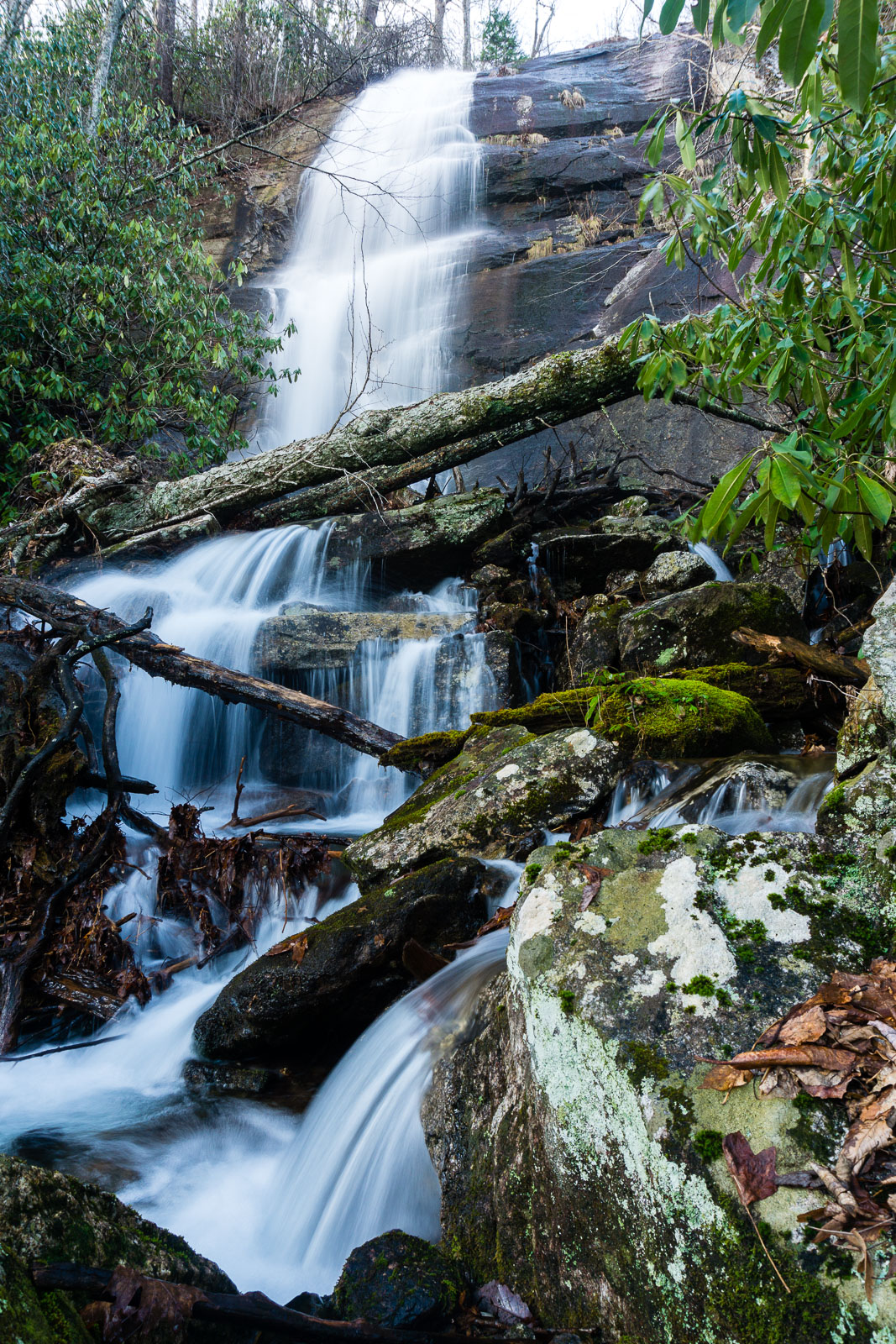
But despite being a high, pretty waterfall close to a major highway, it appears to be relatively unknown with little in the way of evidence of people visiting it. If you promise to Leave No Trace, and are at all familiar with off-trail hiking, this one is highly recommended. The biggest challenge here was simply not slipping into the creek where I crossed it to get a picture, and not disturbing the lush greenery growing on the rocks below the falls.
An old logging road – FS 5032, now grassed-over and open to hiking – splits off from FS 475B (Headwaters Road) and ends in a small clearing just below the falls, providing an alternate access route. From its end, I could barely see but easily hear the falls. You could hike to the end of that road and wander up to the falls from there; or, you could do what I did, and take the trail up the stream to the falls and the road back, making a loop hike. I did this to prolong my time in the woods a bit.
The road passes through some more clearings. I went slowly, snapping pictures of the developing sunset above the open grassy areas lined with tall trees. At one point there were some vernal pools on the road containing blobs of frog eggs. Now that the weather is turning cooler, I hope those little guys survive any ice that forms to see spring!
A few more streams flow under the grassy road. On a whim, I turned up one of them, winding gently uphill into another grassy wildlife opening. Lo and behold, I spotted another waterfall coming off the ridge up above the meadow. That one also had an easy trail leading right up to its base. It was a bit more difficult to get into position for a decent picture, however. After a failed attempt at slip-sliding my way up the creek bed toward the bottom of the falls, I was forced to go back down, cross the creek downstream a bit, and go up the ridge until an opening presented itself through the trees. But it was worth it, because here’s what I saw:
There are a couple more drops above the section shown in this photo. It’s definitely worth a stop if you’re hiking on FS 5032. I slipped out of the cove with the light beginning to fade quickly.
After passing the gate on FS 5032, I turned left on FS 475B for about 0.2 mi. to US 276, then followed it for another 0.2 mi. back to my parking spot. I just just enough light to make it back without really needing a flashlight – although I did break it out when I dropped a key trying to fumble the door lock open. Glad I brought one this time!
Here’s some video from the upper falls on the tributary of Thompson Creek, and the falls on Poundingmill Branch.
Map Note: once again, I forgot to turn on my GPS until I’d already reached the falls, so the map below shows only my Poundingmill hike, starting at the falls and taking the road back. Connect the ends of the red line to see the approximate route I initially followed up the creek.
[map style=”width: 100%; height: 400px;” gpx=”/wp-content/uploads/2016/01/2015-12-31-Falls-on-Poundingmill-Branch.gpx”]
Leave a Reply